Rachel McDonnell
Painter

Deep Encounters - a multifaceted mapping of a small piece of land
Deep Encounters is a project involving 13 artists working in different areas/locations. Working collaboratively, but from different parts of the world, there will be periodic conversations about how we are each representing our piece of land, and ideas for shared activities. Identifying their area of study via Google mapping / OS map / w3ws, each artist will walk the perimeter of their area, tracing the outline, recording what it contains using photos, words, drawings, maps, sound etc. Walking our chosen places, getting to know them, activities and engagements will develop gradually from a growing familiarity. And we will be playful in our responses!
Artists participating: Zoe Ashbrook , Ruth Broadbent, Alison Berrett, Sara Dudman, Ffin(vc Price), Tamsin Grainger, Richard Keating, Melinda Hunt, Janette Kerr, Rachel McDonnell, Amanda Steer, Sally Stenton, Amanda Steer, Molly Wagner.
This is an exercise in deep mapping; an intensive look at a particular place that might include geography, history, and ecology. Some call the approach ‘vertical travel writing’, while archaeologist Michael Shanks compares it to the eclectic approaches of 18th-early 19th century antiquarian topographers, or the psycho-geographic excursions of the early Situationists.
‘…..Places are not stable; they mean different things to different people – even different things at different times. The deep map recognises the slippery identity of place, and seeks to visualise the multiple identities that go towards constructing the human experience of place'.
https://wp.lancs.ac.uk/lakesdeepmap/the-project/gis-deep-mapping/
We increasingly need to work in “the curious space between wonder and thought” a space where….“there is no single Disciplinary (in an academic sense) voice” (geographers Stephan Harrison, Steve Pile, Nigel Thrift), …. the: “space–between representation and reality, language and life, category and experience” (feminist philosopher Geraldine Finn).. (see https://www.iainbiggs.co.uk/2014/10/deep-mapping-a-partial-view/)

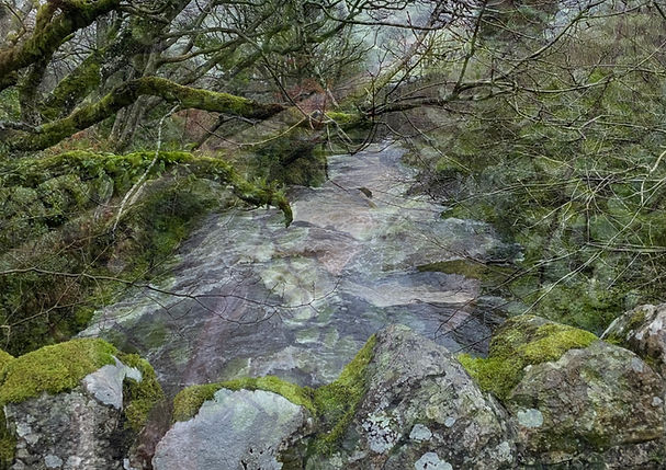
Glenarm - either side of the river
My chosen place is a patch of land in Glenarm, Co. Antrim, a river, a bit on either side (one a temperate rainforest type bit of woodland which is an Ulster Wildlife Trust reserve, one pasture), and a bridge crossing the river on one side of the patch I’ve chosen. It used to be part of a Deer Park, so both sides of the river started out from the same place, but what has been done since has left them as very different places.
It’s where my Dad was from, about 15 minutes walk from his house, which is visible on the top right of the map of my walk, and is somewhere I spent a lot of time when I was young. We used to have picnics in the woods, and I’ve done the same with my kids. I’ve been wanting to do some work there for a very long time, and as I’m going to be coming and going quite a bit in the coming year as my Dad left me his house, which needs quite a lot of attention, I thought this might be the moment to make a start. There’s so much going on in the woods and around, it’s hard to know where to begin, so the commitment to someone other than myself is probably the only way I’ll get going. I am hugely looking forward to getting to know the place in a different way.
Encounter 1 - 30th January 2020
Mapping the Edges on a Cold, Dark and Wet Day
But Wonderful


The Constant Roaring of the River
Starting to Look
So Much Rain (the most in 149 years, I later discovered)
Hazel
The Remains of Summer Picnic Fires
Epiphytic Ferns
Tussocks
Sheep Tracks in the Wood
So Much


Crossing

My Favourite Tree
Memories
The Contorted Limbs of Old Irish Oaks


Bright in the January Dull
Bracken Stalks
A Hard Day, A Good Place to Be

Walking in Pairs - A Walking the Land Project
Walking in Pairs is a collaborative project open to members of Walking the Land and others. It uses walking art to enquire into the nature of creative connection and influence over geographical distance. The artists are walking together in spirit, but apart in location. Curious about the influence one has on the other’s work, they will have created a bond through intention and common interest, and will be actively investigating the relationship, personally, and through creative output. This is embodied research into the nature of influence, looking at possible correlations and common themes that may or may not emerge despite there being geographical distance between the artists. The pairs agree the sort of walk they will take, in advance: duration, location, and perhaps media or materials to be used. Contributing artists may or may not have worked together previously. Walking in Pairs is led by Tamsin Grainger, and I am walking with Sara Dudman, an artist whose work I've long known and admired, but I hadn't previously met.


Walk 1: 16th September 2025
Trying To Think About Trees
Shared Distractions
Autumn Imposing Itself
Shaggy Ink Caps, Extraordinarily Prolific Acorns, Fungi, Colour

Walk 2: 1st October 2026
Walking Together
Introducing My Place
Sara Collecting Soils


Walk 3: 10th October 2025
Trees Under Stress
Coincidences:
The Sound of a Chainsaw
Sara Making Rubbings
Me Painting
Developing Ideas